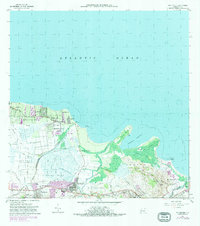
1963 Map of Rio Grande
USGS Topo · Published 1982About this map
Río Grande serves as the inland hub for this coastal region, where the Río Grande de Loíza and Río Herrera meet the Atlantic Ocean. The landscape transition from the swampy wetlands of Ciénaga Baja to the prominent coastal features like Punta Miquillo and Punta Picúa reveals the complex hydrology of the Puerto Rican shoreline before extensive modern development. Smaller communities such as Suárez, Honduras, and Medianía Alta are scattered across the lowlands, while industrial and logistical markers like the Via del Ferrocarril and a Pista de Aterrizaje suggest the transportation networks connecting these settlements. The map also captures local civic life through labeled institutions like Escuela Luis Calderón and Escuela Juan González, alongside recreational spaces like the Campo de Golf near the mouth of the Espíritu Santo.
Find a feature on this map
59 named features on this map. Tap any name to fly to it.
Don’t see what you’re looking for? This feature index may not catch every label — zoom into the map to look around manually.
Map Details
Editions of this 1963 Rio Grande Map
4 editions found
Other maps of this area

1940 · Carolina
USGS Topo · 1:30,000

1941 · Rio Grande
USGS Topo · 1:30,000

1941 · Carolina
USGS Topo · 1:30,000

1945 · El Yunque
USGS Topo · 1:30,000

1946 · El Yunque
USGS Topo · 1:30,000

1946 · Gurabo
USGS Topo · 1:30,000

1946 · Fajardo
USGS Topo · 1:30,000

1947 · Carolina
USGS Topo · 1:30,000

1947 · El Yunque NE
USGS Topo · 1:10,000

1947 · Gurabo NE
USGS Topo · 1:10,000