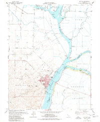
1978 Map of Rio Vista
USGS Topo · Published 1978About this map
The Sacramento River flows past the riverfront city of Rio Vista, anchoring a landscape defined by complex waterways and delta reclaimed lands. By the late 1970s, the area reflects a sophisticated hydraulic engineering system featuring the Yolo Bypass and the Sacramento River Deep Water Ship Channel, alongside vital local infrastructure like the Rio Vista Airport. The map highlights the intersection of agrarian life and industrial energy, with the Montezuma Hills and Rio Vista Gas Field providing a backdrop to the numerous sloughs that carve through Ryer Island and Grand Island. Genealogists will find local institutions such as White Sch and Riverview Sch clearly marked, while the presence of the U S Coast Guard Res underscores the region's importance to maritime safety and navigation within the Sacramento-San Joaquin Delta.
Find a feature on this map
35 named features on this map. Tap any name to fly to it.
Don’t see what you’re looking for? This feature index may not catch every label — zoom into the map to look around manually.
Map Details
Editions of this 1978 Rio Vista Map
3 editions found
Other maps of this area

1907 · Antioch
USGS Topo · 1:62,500

1908 · Vacaville
USGS Topo · 1:62,500

1908 · Courtland
USGS Topo · 1:62,500

1908 · Antioch
USGS Topo · 1:62,500

1910 · Rio Vista
USGS Topo · 1:31,680

1910 · Bouldin
USGS Topo · 1:31,680

1910 · Jersey
USGS Topo · 1:31,680

1910 · Isleton
USGS Topo · 1:31,680

1916 · Cache Slough
USGS Topo · 1:31,680

1916 · Vorden
USGS Topo · 1:31,680