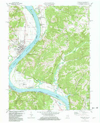
1981 Map of Rising Sun
USGS Topo · Published 1982About this map
Rising Sun dominates the Indiana side of the Ohio River in this detailed 1980s-era study, sitting across from the Kentucky landing of Rabbit Hash. The map captures the distinct topography of the river valley, where narrow alluvial plains like Upper East Bend Bottom contrast with the dissected hills of the Kentucky interior. A dense concentration of family and community landmarks, such as Cedar Hedge Cem and the Waterloo Ch, speaks to a long-established rural settlement pattern on both sides of the state line. At the southeastern corner, the landscape transitions toward the unique geological and paleontological terrain of Big Bone Lick State Park, situated along Big Bone Creek. The presence of large-scale infrastructure like the Powerplant and several Gravel Pits illustrates the industrial utility of the river corridor alongside traditional agricultural communities like Hamilton and Belleview.
Find a feature on this map
75 named features on this map. Tap any name to fly to it.
Don’t see what you’re looking for? This feature index may not catch every label — zoom into the map to look around manually.
Map Details
Editions of this 1981 Rising Sun Map
Other maps of this area

1914 · West Cincinnati
USGS Topo · 1:62,500

1915 · Lawrenceburg
USGS Topo · 1:48,000

1928 · Lawrenceburg
USGS Topo · 1:62,500

1932 · Lawrenceburg
USGS Topo · 1:62,500

1943 · Florence
USGS Topo · 1:24,000

1943 · Aberdeen
USGS Topo · 1:24,000

1943 · Aurora
USGS Topo · 1:24,000

1943 · Rising Sun
USGS Topo · 1:24,000

1943 · Lawrenceburg
USGS Topo · 1:24,000

1943 · Patriot
USGS Topo · 1:24,000