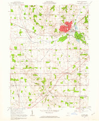
1961 Map of Rittman
USGS Topo · Published 1962About this map
Industrial expansion and rural survey lines meet at the Medina and Wayne County border in the early 1960s. The city of Rittman dominates the northeast, where the Erie-Lackawanna and Baltimore and Ohio railroads converge near substantial extraction operations at the Salt Wells. The landscape is a complex intersection of historic boundaries, including the North Boundary Congress Lands, the Connecticut Western Reserve, and the Old Seven Ranges. These surveyors' lines divide a terrain shaped by Chippewa Creek and its tributaries, while small agricultural hubs like Sterling and Milton maintain a network of country schools and churches. Genealogists will find a wealth of burial grounds, from the Flickinger Cem to the Shinersburg Cem, documenting the area's established families.
Find a feature on this map
48 named features on this map. Tap any name to fly to it.
Don’t see what you’re looking for? This feature index may not catch every label — zoom into the map to look around manually.
Map Details
Editions of this 1961 Rittman Map
Other maps of this area

1901 · Massillon
USGS Topo · 1:62,500

1901 · Wooster
USGS Topo · 1:62,500

1903 · Massillon
USGS Topo · 1:62,500

1903 · Wooster
USGS Topo · 1:62,500

1903 · Akron
USGS Topo · 1:62,500

1904 · Medina
USGS Topo · 1:62,500

1905 · Akron
USGS Topo · 1:62,500

1906 · Medina
USGS Topo · 1:62,500

1950 · Cleveland
USGS Topo · 1:250,000

1951 · Canton
USGS Topo · 1:250,000