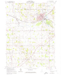
1961 Map of Rittman
USGS Topo · Published 1974About this map
Industrial and agricultural activity converge where the Baltimore and Ohio and Erie-Lackawanna railroads intersect in Rittman. This 1961 survey captures the town's complex layout, featuring the High School, City Hall, and a dedicated Swimming Pool near the River Styx. The surrounding countryside reveals a landscape defined by significant resource extraction, prominently marked by numerous Salt Wells and a Sand and Gravel Pit.
Find a feature on this map
46 named features on this map. Tap any name to fly to it.
Don’t see what you’re looking for? This feature index may not catch every label — zoom into the map to look around manually.
Map Details
Editions of this 1961 Rittman Map
Other maps of this area

1901 · Massillon
USGS Topo · 1:62,500

1901 · Wooster
USGS Topo · 1:62,500

1903 · Massillon
USGS Topo · 1:62,500

1903 · Wooster
USGS Topo · 1:62,500

1903 · Akron
USGS Topo · 1:62,500

1904 · Medina
USGS Topo · 1:62,500

1905 · Akron
USGS Topo · 1:62,500

1906 · Medina
USGS Topo · 1:62,500

1950 · Cleveland
USGS Topo · 1:250,000

1951 · Canton
USGS Topo · 1:250,000