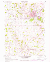
1961 Map of Rittman
USGS Topo · Published 1978About this map
Rittman and Sterling anchor this landscape during a period of transition, where industrial salt production and agriculture meet the expanding urban footprints of the late 1970s. The map illustrates a dense concentration of Salt Wells and a Sand and Gravel Pit near the Styx River confluence, marking the economic drivers of the era. A complex network of rail transport, including the Baltimore and Ohio, Erie-Lackawanna, and New York Chicago and St Louis railroads, converges around the settlements, highlighting the region's importance as a freight corridor.
Find a feature on this map
50 named features on this map. Tap any name to fly to it.
Don’t see what you’re looking for? This feature index may not catch every label — zoom into the map to look around manually.
Map Details
Editions of this 1961 Rittman Map
Other maps of this area

1901 · Massillon
USGS Topo · 1:62,500

1901 · Wooster
USGS Topo · 1:62,500

1903 · Massillon
USGS Topo · 1:62,500

1903 · Wooster
USGS Topo · 1:62,500

1903 · Akron
USGS Topo · 1:62,500

1904 · Medina
USGS Topo · 1:62,500

1905 · Akron
USGS Topo · 1:62,500

1906 · Medina
USGS Topo · 1:62,500

1950 · Cleveland
USGS Topo · 1:250,000

1951 · Canton
USGS Topo · 1:250,000