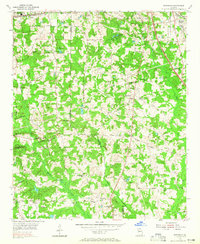
1954 Map of Riverdale
USGS Topo · Published 1965About this map
Riverdale and its surrounding rural community in the mid-1950s serve as the centerpiece of this study, revealing a landscape defined by small churches and family burial grounds. The Central of Georgia rail line cuts through the northeastern corner, passing through Forest Park and past the Philadelphia Ch. This era shows the transition of the northern Clayton County and southern Fulton County borders before intense suburban expansion. Local spiritual and social life is anchored by numerous landmarks like Pleasant Grove Ch and Bethsaida Ch, while the agricultural roots of the area are evident in the scattered family cemeteries such as Adams Cem and Mundy Cem. Significant waterways like the Flint River and Camp Creek drain the undulating terrain, punctuated by early community hubs like the Civic Club and Red Oak.
Find a feature on this map
56 named features on this map. Tap any name to fly to it.
Don’t see what you’re looking for? This feature index may not catch every label — zoom into the map to look around manually.
Map Details
Editions of this 1954 Riverdale Map
5 editions found

Other maps of this area

1888 · Atlanta
USGS Topo · 1:125,000

1890 · Atlanta
USGS Topo · 1:125,000

1891 · Marietta
USGS Topo · 1:125,000

1892 · Atlanta
USGS Topo · 1:125,000

1895 · Atlanta
USGS Topo · 1:125,000

1895 · Marietta
USGS Topo · 1:125,000

1897 · Marietta
USGS Topo · 1:125,000

1901 · Marietta
USGS Topo · 1:125,000

1953 · Atlanta
USGS Topo · 1:250,000

1954 · Conley
USGS Topo · 1:24,000