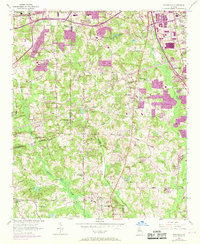
1954 Map of Riverdale
USGS Topo · Published 1969About this map
Riverdale serves as the focal point of this mid-century landscape where the rural agricultural past met the early stages of suburban expansion south of Atlanta. Surveyed in the 1950s and updated with 1968 aerial data, the map reveals a high density of country churches that anchored these communities, including Bethel Ch, Pleasant Hill Ch, and Bethsaida Ch. The Central of Georgia railroad tracks cut a diagonal path through the terrain, connecting the burgeoning town centers of Red Oak and Forest Park to the surrounding countryside.
Find a feature on this map
53 named features on this map. Tap any name to fly to it.
Don’t see what you’re looking for? This feature index may not catch every label — zoom into the map to look around manually.
Map Details
Editions of this 1954 Riverdale Map
5 editions found

Other maps of this area

1888 · Atlanta
USGS Topo · 1:125,000

1890 · Atlanta
USGS Topo · 1:125,000

1891 · Marietta
USGS Topo · 1:125,000

1892 · Atlanta
USGS Topo · 1:125,000

1895 · Atlanta
USGS Topo · 1:125,000

1895 · Marietta
USGS Topo · 1:125,000

1897 · Marietta
USGS Topo · 1:125,000

1901 · Marietta
USGS Topo · 1:125,000

1953 · Atlanta
USGS Topo · 1:250,000

1954 · Conley
USGS Topo · 1:24,000