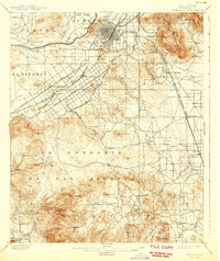
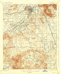
1901 Map of Riverside
USGS Topo · Published 1942About this map
The Santa Ana River winds past the emerging city center of Riverside, illustrating a landscape transitioning from open ranchlands to structured citrus groves and industrial mining at the turn of the century. Large land grants like El Sobrante De San Jacinto and La Sierra dominate the southern half of the sheet, while the northern portion reveals the sophisticated irrigation network that fueled the region's growth. The Gage Canal and Riverside Canal are clearly delineated, tracing the contours below Victoria Hill and Pachappa Hill. Early transportation corridors are well-established, with Magnolia Avenue and Victoria Avenue serving as primary arteries alongside the Southern California R.R. and the San Bernardino and Temecula Line. In the rugged south, industrial sites like the Cajalco Tin Mine and Gavilan Mine sit among peaks such as Monument Pk. and Estelle Mt.
Find a feature on this map
53 named features on this map. Tap any name to fly to it.
Don’t see what you’re looking for? This feature index may not catch every label — zoom into the map to look around manually.
Map Details
Editions of this 1901 Riverside Map
6 editions found
Other maps of this area

1896 · San Bernardino
USGS Topo · 1:62,500

1897 · Cucamonga
USGS Topo · 1:62,500

1898 · San Bernardino
USGS Topo · 1:62,500

1899 · Redlands
USGS Topo · 1:62,500

1900 · Cucamonga
USGS Topo · 1:62,500

1901 · Southern California Sheet No. 1
USGS Topo · 1:250,000

1901 · San Bernardino
USGS Topo · 1:62,500

1901 · Redlands
USGS Topo · 1:62,500

1901 · Elsinore
USGS Topo · 1:125,000

1901 · Riverside
USGS Topo · 1:62,500