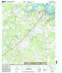
1997 Map of Riverside
USGS Topo · Published 2000About this map
The Trinity River serves as a geographic anchor for this pocket of Walker County, winding through a landscape shaped by both public conservation and rural institutional development. Extensive acreage within the Sam Houston National Forest dominates the southern reaches, while the northern terrain near Riverside is characterized by industrial extractions like the local Gravel Pit and Clay Pit. A significant local landmark is the Sam Houston State Teachers College (Country Campus PO), which occupies a former military or rural training site complete with its own Campus Golf Course.
Find a feature on this map
36 named features on this map. Tap any name to fly to it.
Don’t see what you’re looking for? This feature index may not catch every label — zoom into the map to look around manually.
Map Details
Editions of this 1997 Riverside Map
This is the sole edition of this map. No revisions or reprints were ever made.
Other maps of this area

1954 · Beaumont
USGS Topo · 1:250,000

1957 · Beaumont
USGS Topo · 1:250,000

1960 · Trinity West
USGS Topo · 1:24,000

1960 · Trinity East
USGS Topo · 1:24,000

1960 · Phelps
USGS Topo · 1:24,000

1961 · Staley
USGS Topo · 1:24,000

1961 · Riverside
USGS Topo · 1:24,000

1961 · Oakhurst
USGS Topo · 1:24,000

1962 · Pine Prairie
USGS Topo · 1:24,000

1962 · Wyser Bottom
USGS Topo · 1:24,000