
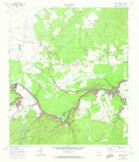
1962 Map of Wyser Bottom
USGS Topo · Published 1965About this map
The Eastham State Prison Farm dominates the northwestern landscape of this East Texas terrain, characterized by the winding course of the Trinity River. The river creates a complex hydrology of sloughs, shoals, and oxbow lakes, such as Horseshoe Lake and Mason Slough. Along the southern banks, prominent elevations rise at Cincinnati Bluff and Wyser Bluff, overlooking the low-lying Wyser Bottom. This area preserves several family and community landmarks, including the New Hope Ch and a collection of small burial grounds like Spivey Cem and Dunlap Cem. The presence of Cincinnati Cem and Cincinnati Shoals serves as a reminder of the vanished river town of Cincinnati, which once served as a vital shipping point before being bypassed by railroads. Local history is further marked by features such as Lost Indian Camp and numerous named drainages like Jenkins Branch and Polecat Branch.
Find a feature on this map
51 named features on this map. Tap any name to fly to it.
Don’t see what you’re looking for? This feature index may not catch every label — zoom into the map to look around manually.
Map Details
Editions of this 1962 Wyser Bottom Map
2 editions found
Other maps of this area

1953 · Palestine
USGS Topo · 1:250,000

1954 · Beaumont
USGS Topo · 1:250,000

1957 · Beaumont
USGS Topo · 1:250,000

1957 · Palestine
USGS Topo · 1:250,000

1960 · Trinity West
USGS Topo · 1:24,000

1961 · Riverside
USGS Topo · 1:24,000

1962 · Pine Prairie
USGS Topo · 1:24,000

1962 · Lovelady South
USGS Topo · 1:24,000

1962 · Baker Lake
USGS Topo · 1:24,000

1963 · Crabbs Prairie
USGS Topo · 1:24,000