
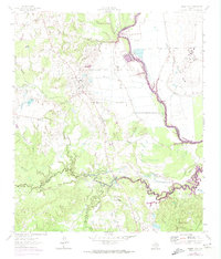
1962 Map of Baker Lake
USGS Topo · Published 1966About this map
The Trinity River snakes through the bottomlands of this Texas interior, serving as the county line between Houston, Madison, and Walker counties in the early 1960s. The landscape is defined by its institutional use and rural isolation, dominated by the massive acreage of the Ferguson State Prison Farm and Eastham State Prison Farm. These sprawling state properties sit amidst a network of creek branches like Larrison Creek and Bedias Creek, where local life is anchored by small community centers. Genealogists will find interest in the pairing of religious and educational sites, such as the Shaw Prairie Ch and Shaw Prairie Sch, alongside the Hopewell Ch and Hopewell Sch. Further north, the settlement of Bald Prairie and nearby Bucks Cem mark the human geography of a region shaped by correctional agriculture and deep-rooted rural congregations.
Find a feature on this map
27 named features on this map. Tap any name to fly to it.
Don’t see what you’re looking for? This feature index may not catch every label — zoom into the map to look around manually.
Map Details
Editions of this 1962 Baker Lake Map
2 editions found
Other maps of this area

1953 · Palestine
USGS Topo · 1:250,000

1954 · Beaumont
USGS Topo · 1:250,000

1957 · Beaumont
USGS Topo · 1:250,000

1957 · Palestine
USGS Topo · 1:250,000

1962 · Pine Prairie
USGS Topo · 1:24,000

1962 · Connor
USGS Topo · 1:24,000

1962 · Wyser Bottom
USGS Topo · 1:24,000

1963 · Steep Branch
USGS Topo · 1:24,000

1963 · Crabbs Prairie
USGS Topo · 1:24,000

1964 · Sand Ridge
USGS Topo · 1:24,000