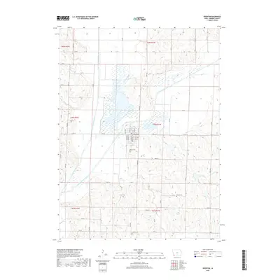
2018 Map of Riverton
USGS Topo · Published 2018About this map
The confluence of the West Nishnabotna River and East Nishnabotna River dominates this landscape in Fremont County, where the town of Riverton serves as the local hub. This 2018 survey reveals a terrain defined by broad river bottomlands and intricate drainage patterns from smaller tributaries like Spring Br, Mill Cr, and Ledgewood Cr. The map is particularly useful for genealogical research, identifying several family and community burial grounds dispersed across the townships, including Redd Cem in the northwest, Stauch Cem, and the Wesleyan Cem. The grid of county roads, such as Co Rd J46 and Co Rd L64, connects these rural sites to the central settlement of Riverton, illustrating the enduring agricultural and civic structure of this southwestern Iowa region.
Find a feature on this map
37 named features on this map. Tap any name to fly to it.
Don’t see what you’re looking for? This feature index may not catch every label — zoom into the map to look around manually.
Map Details
Editions of this 2018 Riverton Map
This is the sole edition of this map. No revisions or reprints were ever made.
Other maps of this area

1939 · Farragut
USGS Topo · 1:62,500

1939 · Hamburg
USGS Topo · 1:62,500

1940 · Farragut
USGS Topo · 1:62,500

1941 · Hamburg
USGS Topo · 1:62,500

1955 · Nebraska City
USGS Topo · 1:250,000

1957 · Nebraska City
USGS Topo · 1:250,000

1957 · Randolph
USGS Topo · 1:24,000

1957 · Tabor SW
USGS Topo · 1:24,000

1958 · Nebraska City
USGS Topo · 1:250,000
1966 · Hamburg
USGS Topo · 1:24,000