
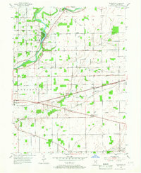
1953 Map of Riverwood
USGS Topo · Published 1955About this map
The White River carves a winding path through this central Indiana landscape, anchoring a network of small agricultural settlements and crossroads. Near the river bend, the community of Riverwood sits adjacent to industrial markers of the era, including Transformer Yards, a Power Sta, and a Gaging Sta. Further east, the village of Strawtown and the hamlet of Clare are connected by a rural road network that intersects with the Chicago and St Louis and Central Indiana rail lines.
Find a feature on this map
36 named features on this map. Tap any name to fly to it.
Don’t see what you’re looking for? This feature index may not catch every label — zoom into the map to look around manually.
Map Details
Editions of this 1953 Riverwood Map
2 editions found
Other maps of this area

1952 · Fishers
USGS Topo · 1:24,000

1952 · Ingalls
USGS Topo · 1:24,000

1952 · Mc Cordsville
USGS Topo · 1:24,000

1953 · Lapel
USGS Topo · 1:24,000

1953 · Noblesville
USGS Topo · 1:24,000

1953 · Cincinnati
USGS Topo · 1:250,000

1953 · Danville
USGS Topo · 1:250,000

1953 · Indianapolis
USGS Topo · 1:250,000

1953 · Muncie
USGS Topo · 1:250,000

1955 · Danville
USGS Topo · 1:250,000