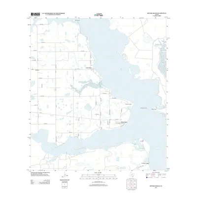
2013 Map of Riviera Beach
USGS Topo · Published 2013About this map
Baffin Bay and its intricate northern inlets dominate this coastal landscape of South Texas. The map details the convergence of Cayo del Grullo and Laguna Salada, separated by a finger of land terminating at Neubauer Point. Along these shorelines, small settlements like Riviera Beach and Loyola Beach provide access to the water, while further inland, the community of Vattman sits amidst a grid of county roads and intermittent drainage features like Araña Cr. To the south, La Parra Landing marks the edge of the bay near Pie de Gallo. This coastal geography is characterized by sensitive tidal environments, where Los Olmos Creek feeds into the western reaches of the bay system, creating a complex network of points, rocks, and marshes including Neubauer Rocks and Sandy Hook.
Find a feature on this map
51 named features on this map. Tap any name to fly to it.
Don’t see what you’re looking for? This feature index may not catch every label — zoom into the map to look around manually.
Map Details
Editions of this 2013 Riviera Beach Map
This is the sole edition of this map. No revisions or reprints were ever made.
Other maps of this area

1928 · Sarita
USGS Topo · 1:125,000

1950 · Corpus Christi
USGS Topo · 1:250,000

1951 · Kleberg Point
USGS Topo · 1:24,000

1951 · Riviera Beach NE
USGS Topo · 1:24,000

1951 · Sarita 4 NE
USGS Topo · 1:24,000

1952 · Riviera Beach
USGS Topo · 1:24,000

1952 · La Parra Ranch
USGS Topo · 1:24,000

1952 · Riviera Beach NW
USGS Topo · 1:24,000

1952 · Riviera Beach
USGS Topo · 1:62,500

1954 · Sarita
USGS Topo · 1:62,500