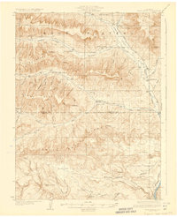
1929 Map of Roan Creek
USGS Topo · Published 1929About this map
Book Plateau and the surrounding high-altitude geography of western Colorado define this 1920s topography, showing a landscape shaped by drainage basins and early industrial interest. The Index Shale Plant stands as a significant industrial marker in a region otherwise characterized by isolated homesteads like Wilcoxson Ranch and Goslin Ranch. To the south, the Denver and Rio Grande Western railroad tracks follow the corridor of the Colorado River, connecting the remote draws and ridges to larger markets. Education in this ranching country was localized, as evidenced by the distribution of the Kimball Creek Sch, Conn Creek Sch, and Dry Fork Sch. The terrain is deeply incised by numerous seasonal and permanent watercourses, including Roan Creek and Alkali Canyon, which dictated the placement of early routes such as the Beer Park Trail and the eponymous Wagon Track Ridge.
Find a feature on this map
44 named features on this map. Tap any name to fly to it.
Don’t see what you’re looking for? This feature index may not catch every label — zoom into the map to look around manually.
Map Details
Editions of this 1929 Roan Creek Map
3 editions found
Other maps of this area

1925 · Parachute Creek
USGS Topo · 1:62,500

1927 · Parachute Creek
USGS Topo · 1:62,500

1929 · Grand Valley
USGS Topo · 1:62,500

1929 · Highmore
USGS Topo · 1:62,500

1929 · Roan Creek
USGS Topo · 1:62,500

1955 · Cameo
USGS Topo · 1:24,000

1955 · Mesa
USGS Topo · 1:24,000

1956 · Grand Junction
USGS Topo · 1:250,000

1959 · Grand Junction
USGS Topo · 1:250,000

1960 · Grand Junction
USGS Topo · 1:250,000