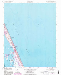
1953 Map of Roanoke Island NE
USGS Topo · Published 1983About this map
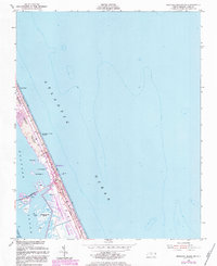
The shifting sands of the Outer Banks define this coastal landscape, where the Nags Head corporate boundary marks the edge of the developing seaside community. Surveyed in the early 1950s and updated with photorevisions in the 1980s, the map documents a narrow strip of land dominated by Shifting Sand Dunes and the infrastructure of the Cape Hatteras National Seashore. The proximity of the Atlantic Ocean and the Roanoke Sound is bridged by a prominent Causeway connecting to Roanoke Island. Along the oceanfront, the U S Coast Guard Station and Jeanettes Pier serve as focal points for maritime safety and recreation. The geography reveals a collection of small marsh islands, including Big Penguin I and Little Penguin I, while a Hatteras Telephone Line runs parallel to the coast, indicating the critical utility corridors needed for these barrier island settlements.
Find a feature on this map
23 named features on this map. Tap any name to fly to it.
Don’t see what you’re looking for? This feature index may not catch every label — zoom into the map to look around manually.
Map Details
Editions of this 1953 Roanoke Island NE Map
6 editions found
Other maps of this area

1940 · Kitty Hawk
USGS Topo · 1:62,500

1943 · Roanoke Island
USGS Topo · 1:125,000

1946 · Eastville
USGS Topo · 1:250,000

1946 · Currituck Sound
USGS Topo · 1:250,000

1953 · Wanchese
USGS Topo · 1:24,000

1953 · Roanoke Island NE
USGS Topo · 1:24,000

1953 · Manteo
USGS Topo · 1:24,000

1955 · Wanchese
USGS Topo · 1:250,000

1957 · Manteo
USGS Topo · 1:250,000

1960 · Manteo
USGS Topo · 1:250,000