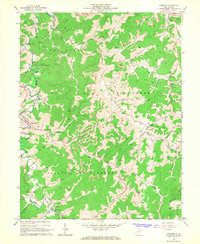
1966 Map of Roanoke
USGS Topo · Published 1968About this map
The West Fork River winds through this central West Virginia landscape, anchoring small settlements like Roanoke and Jacksonville during the mid-1960s. The region is defined by its complex drainage network, where Skin Creek and Stonecoal Creek feed the larger river system alongside numerous runs named for early families. The extraction of natural resources is evident through scattered gas wells and a prominent Strip Mine near the center of the map, illustrating the intersection of traditional Appalachian farming and industrial activity.
Find a feature on this map
65 named features on this map. Tap any name to fly to it.
Don’t see what you’re looking for? This feature index may not catch every label — zoom into the map to look around manually.
Map Details
Editions of this 1966 Roanoke Map
3 editions found
Other maps of this area

1893 · Buckhannon
USGS Topo · 1:125,000

1893 · Sutton
USGS Topo · 1:125,000

1896 · Buckhannon
USGS Topo · 1:125,000

1897 · Buckhannon
USGS Topo · 1:125,000

1904 · Weston
USGS Topo · 1:62,500

1904 · Vadis
USGS Topo · 1:62,500

1906 · Burnsville
USGS Topo · 1:62,500

1912 · Crawford
USGS Topo · 1:48,000

1914 · Crawford
USGS Topo · 1:62,500

1925 · Burnsville
USGS Topo · 1:62,500