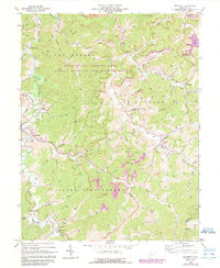
1966 Map of Roanoke
USGS Topo · Published 1989About this map
Small settlements and rural church sites dot the valley of the West Fk River and its numerous winding tributaries during the mid-1960s. The landscape of Court House and Collins Settlement is defined by a dense network of extraction points, with scores of Gas Wells and Oil Wells peppered across the ridgelines near Roanoke and Vandalia. This era shows the early integration of resource management and recreation, specifically noting the Stonewall Jackson Lake Public Hunting and Fishing Area and the Stonecoal Reservoir in the northeast.
Find a feature on this map
69 named features on this map. Tap any name to fly to it.
Don’t see what you’re looking for? This feature index may not catch every label — zoom into the map to look around manually.
Map Details
Editions of this 1966 Roanoke Map
3 editions found
Other maps of this area

1893 · Buckhannon
USGS Topo · 1:125,000

1893 · Sutton
USGS Topo · 1:125,000

1896 · Buckhannon
USGS Topo · 1:125,000

1897 · Buckhannon
USGS Topo · 1:125,000

1904 · Weston
USGS Topo · 1:62,500

1904 · Vadis
USGS Topo · 1:62,500

1906 · Burnsville
USGS Topo · 1:62,500

1912 · Crawford
USGS Topo · 1:48,000

1914 · Crawford
USGS Topo · 1:62,500

1925 · Burnsville
USGS Topo · 1:62,500