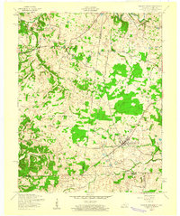
1957 Map of Roaring Spring
USGS Topo · Published 1960About this map
The Fort Campbell Military Reservation dominates the southern half of this landscape, marking a period of significant military transition across the Kentucky and Tennessee border. Just north of the reservation line, the rural character of Trigg and Christian Counties is preserved in small settlements like Roaring Spring and Corinth. The village of Lafayette serves as a local hub near the eastern edge, situated along the Lafayette Road.
Find a feature on this map
21 named features on this map. Tap any name to fly to it.
Don’t see what you’re looking for? This feature index may not catch every label — zoom into the map to look around manually.
Map Details
Editions of this 1957 Roaring Spring Map
3 editions found
Other maps of this area

1950 · Caledonia
USGS Topo · 1:24,000

1951 · Church Hill
USGS Topo · 1:24,000

1951 · Caledonia
USGS Topo · 1:24,000

1951 · Roaring Spring
USGS Topo · 1:24,000

1951 · Johnson Hollow
USGS Topo · 1:24,000

1951 · Indian Mound
USGS Topo · 1:24,000

1951 · Bumpus Mills
USGS Topo · 1:24,000

1951 · Herndon
USGS Topo · 1:24,000

1951 · Woodlawn
USGS Topo · 1:24,000
1953 · Cadiz
USGS Topo · 1:24,000