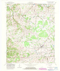
1957 Map of Roaring Spring
USGS Topo · Published 1983About this map
Roaring Spring and La Fayette anchor this mid-century portrait of the Kentucky-Tennessee borderlands. The landscape is dominated by the northern reaches of the Fort Campbell Military Reservation, which spans across the Trigg and Christian county lines. The map reveals a transition between agricultural community centers and military land use, with an Airfield situated near the Stewart County line in Tennessee. Along the undulating terrain, local spiritual life is marked by Corinth Ch and Antioch Ch, while the natural drainage of the region is defined by Skinner Cr and the winding course of the Little River. This survey captures the rural road network, including the prominent Lafayette Road, providing a detailed look at the area's development before late-twentieth-century changes.
Find a feature on this map
16 named features on this map. Tap any name to fly to it.
Don’t see what you’re looking for? This feature index may not catch every label — zoom into the map to look around manually.
Map Details
Editions of this 1957 Roaring Spring Map
3 editions found
Other maps of this area

1950 · Caledonia
USGS Topo · 1:24,000

1951 · Church Hill
USGS Topo · 1:24,000

1951 · Caledonia
USGS Topo · 1:24,000

1951 · Roaring Spring
USGS Topo · 1:24,000

1951 · Johnson Hollow
USGS Topo · 1:24,000

1951 · Indian Mound
USGS Topo · 1:24,000

1951 · Bumpus Mills
USGS Topo · 1:24,000

1951 · Herndon
USGS Topo · 1:24,000

1951 · Woodlawn
USGS Topo · 1:24,000
1953 · Cadiz
USGS Topo · 1:24,000