
1961 Map of Robb
USGS Topo · Published 1963About this map
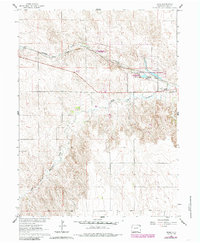
Robb serves as the primary rail-side settlement in this eastern Colorado landscape, situated along the Chicago Burlington and Quincy railroad line. The map highlights a significant concentration of water management and wildlife conservation efforts along Chief Creek, notably the State Fish Hatchery and the adjacent Stalker Lake, which features a recorded spillway elevation.
Find a feature on this map
11 named features on this map. Tap any name to fly to it.
Don’t see what you’re looking for? This feature index may not catch every label — zoom into the map to look around manually.
Map Details
Editions of this 1961 Robb Map
2 editions found
Other maps of this area

1954 · Limon
USGS Topo · 1:250,000

1954 · Sterling
USGS Topo · 1:250,000

1957 · Limon
USGS Topo · 1:250,000

1958 · Limon
USGS Topo · 1:250,000

1958 · Sterling
USGS Topo · 1:250,000

1961 · Eckley
USGS Topo · 1:24,000

1961 · Wray
USGS Topo · 1:24,000

1963 · Vernon
USGS Topo · 1:24,000

1963 · Beecher Island NW
USGS Topo · 1:24,000

1969 · Vernon NW
USGS Topo · 1:24,000