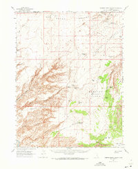
1963 Map of Robbers Roost Canyon
USGS Topo · Published 1973About this map
The San Rafael Desert landscape of southern Utah, as documented by field checks in 1963, reveals a network of springs and canyons vital to the region's ranching history. Remote outposts like the Biddlecone Ranch and North Spring Cabin are mapped alongside crucial water sources such as Robbers Roost Spring and Hooch Spring. The intricate drainage systems of the North Fork, Middle Fork, and South Fork Robbers Roost Canyon converge near Angels Point, illustrating the natural barriers that defined this territory. Several landing strips and the presence of Texas Well suggest 20th-century exploration and resource management, while the Angels Trail and Antelope Valley Corral provide evidence of earlier livestock movement through Antelope Valley. The boundary between Emery Co and Wayne Co bisects these isolated flats and canyonlands.
Find a feature on this map
53 named features on this map. Tap any name to fly to it.
Don’t see what you’re looking for? This feature index may not catch every label — zoom into the map to look around manually.
Map Details
Editions of this 1963 Robbers Roost Canyon Map
3 editions found

Other maps of this area

1885 · San Rafael
USGS Topo · 1:250,000

1952 · Bull Mountain
USGS Topo · 1:62,500

1953 · Orange Cliffs 4 NW
USGS Topo · 1:24,000

1953 · Orange Cliffs 3 NE
USGS Topo · 1:24,000

1953 · Orange Cliffs 3 NW
USGS Topo · 1:24,000

1953 · The Spur
USGS Topo · 1:62,500

1953 · Temple Mtn
USGS Topo · 1:62,500

1953 · Fiddler Butte
USGS Topo · 1:62,500

1953 · Orange Cliffs
USGS Topo · 1:62,500

1954 · Stinking Spring Creek 4 SE
USGS Topo · 1:24,000