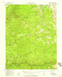
1952 Map of Robbs Peak
USGS Topo · Published 1958About this map
El Dorado National Forest terrain dominates this mid-century survey, revealing a landscape defined by seasonal camps, remote ranches, and water management infrastructure. The high country around Loon Lake and the Rubicon River is dotted with functional outposts like Francis Cow Camp, Witch Camp, and the Schlein Ranger Sta, reflecting the era's reliance on back-country stewardship and grazing. To the south, the South Fork American River corridor serves as the primary artery for settlement, anchored by Kyburz and Riverton.
Find a feature on this map
106 named features on this map. Tap any name to fly to it.
Don’t see what you’re looking for? This feature index may not catch every label — zoom into the map to look around manually.
Map Details
Editions of this 1952 Robbs Peak Map
4 editions found
Other maps of this area

1889 · Pyramid Peak
USGS Topo · 1:125,000

1891 · Colfax
USGS Topo · 1:125,000

1891 · Truckee
USGS Topo · 1:125,000

1891 · Placerville
USGS Topo · 1:125,000

1891 · Pyramid Peak
USGS Topo · 1:125,000

1892 · Placerville
USGS Topo · 1:125,000

1892 · Colfax
USGS Topo · 1:125,000

1893 · Placerville
USGS Topo · 1:125,000

1893 · Truckee
USGS Topo · 1:125,000

1894 · Colfax
USGS Topo · 1:125,000