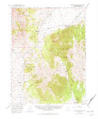
1949 Map of Roberts Creek Mtn
USGS Topo · Published 1982About this map
Simpson Park Mountains and the Roberts Mts frame this 1949 landscape, centered on the high desert basins of Eureka County. Ranching life is the primary human imprint here, with isolated holdings such as Indian Ranch, Tonkin Ranch, and Three Bar Ranch connected by the primitive Tonkin Road. These outposts represent the tenuous settlement patterns of mid-century Nevada, where water sources like Indian Spr, Tonkin Spr, and Rutabaga Spring determined the placement of every homestead. The map reveals the topography of the Red Hills and the winding course of Denay Creek, offering a detailed view of the terrain before modern developments. While the area remains largely open range, a solitary Prospect in the southwest suggests the persistent search for mineral wealth that defines the region’s economic history.
Find a feature on this map
43 named features on this map. Tap any name to fly to it.
Don’t see what you’re looking for? This feature index may not catch every label — zoom into the map to look around manually.
Map Details
Editions of this 1949 Roberts Creek Mtn Map
3 editions found
Other maps of this area

1926 · Roberts Mountains
USGS Topo · 1:250,000

1929 · Roberts Mountains
USGS Topo · 1:250,000

1937 · Mineral Hill
USGS Topo · 1:48,000

1938 · Cortez
USGS Topo · 1:48,000

1943 · Mineral Hill
USGS Topo · 1:62,500

1944 · Cortez
USGS Topo · 1:62,500

1949 · Garden Valley
USGS Topo · 1:62,500

1949 · Roberts Creek Mtn
USGS Topo · 1:62,500

1951 · Roberts Creek Mtn
USGS Topo · 1:62,500

1951 · Garden Valley
USGS Topo · 1:62,500