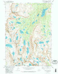
1981 Map of Roberts Mountain
USGS Topo · Published 1982About this map
The Continental Divide zigzags across this high-altitude landscape in the Wind River Range, marking the boundary between the Bridger Wilderness and Shoshone National Forest. This 1981 survey documents a complex glaciated environment where the Wind River Indian Reservation Boundary meets the crest of the range. The map illustrates the hydrography of the region, showing the headwaters of the Wind River and the North Fork Little Wind River. Glacial features such as the Glacier near Lake Heebecheeche are clearly marked, alongside prominent high-elevation landmarks including Mount Lander, Wolverine Peak, and Musembeah Peak. A network of pack trails provides the only access through this wilderness area, connecting remote alpine basins like Bonneville Basin and significant water bodies such as Lake Solitude and Raft Lake.
Find a feature on this map
56 named features on this map. Tap any name to fly to it.
Don’t see what you’re looking for? This feature index may not catch every label — zoom into the map to look around manually.
Map Details
Editions of this 1981 Roberts Mountain Map
2 editions found
Other maps of this area

1937 · Moccasin Lake
USGS Topo · 1:48,000

1938 · Mt Bonneville
USGS Topo · 1:62,500

1941 · Mt Bonneville
USGS Topo · 1:62,500

1942 · Mt Bonneville
USGS Topo · 1:62,500

1943 · Moccasin Lake
USGS Topo · 1:62,500

1952 · Paradise Basin
USGS Topo · 1:24,000

1952 · St. Lawrence Basin
USGS Topo · 1:24,000

1952 · Alpine Lake
USGS Topo · 1:24,000

1955 · Thermopolis
USGS Topo · 1:250,000

1955 · Lander
USGS Topo · 1:250,000