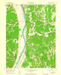
1958 Map of Robertsburg
USGS Topo · Published 1960About this map
The Kanawha River serves as the central artery for this 1950s landscape, flanked by the New York Central railroad tracks that connect small riverbank settlements like Robertsburg and Grimms Landing. To the west, the deeply dissected topography includes the Chief Cornstalk Hunting Grounds, while the east is defined by a dense network of ridges such as Calispell Ridge and Buffalo Ridge.
Find a feature on this map
59 named features on this map. Tap any name to fly to it.
Don’t see what you’re looking for? This feature index may not catch every label — zoom into the map to look around manually.
Map Details
Editions of this 1958 Robertsburg Map
Other maps of this area

1906 · Glenwood
USGS Topo · 1:62,500

1906 · Winfield
USGS Topo · 1:62,500

1908 · Glenwood
USGS Topo · 1:62,500

1908 · Winfield
USGS Topo · 1:62,500

1908 · Ravenswood
USGS Topo · 1:62,500

1908 · Point Pleasant
USGS Topo · 1:62,500

1926 · Ravenswood
USGS Topo · 1:62,500

1926 · Point Pleasant
USGS Topo · 1:62,500

1928 · Ravenswood
USGS Topo · 1:62,500

1929 · Point Pleasant
USGS Topo · 1:62,500