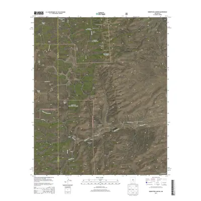
2013 Map of Robertson Canyon
USGS Topo · Published 2013About this map
The Sacramento Mountains define this high-altitude landscape along the border of Otero and Chaves counties. This 2013 survey of the Lincoln National Forest illustrates a complex network of drainages and seasonal water sources essential for land management. Named canyons such as Robertson Canyon, Angel Canyon, and Big Cherry Canyon carve through the terrain, while the course of Bluewater Cr winds through the southern reaches.
Find a feature on this map
39 named features on this map. Tap any name to fly to it.
Don’t see what you’re looking for? This feature index may not catch every label — zoom into the map to look around manually.
Map Details
Editions of this 2013 Robertson Canyon Map
This is the sole edition of this map. No revisions or reprints were ever made.
Other maps of this area

1954 · Carlsbad
USGS Topo · 1:250,000

1958 · Carlsbad
USGS Topo · 1:250,000

1962 · Dunken
USGS Topo · 1:62,500

1963 · Mayhill
USGS Topo · 1:24,000

1963 · Robertson Canyon
USGS Topo · 1:24,000

1963 · Woodson Canyon
USGS Topo · 1:24,000
1963 · Elk
USGS Topo · 1:24,000

1965 · Chimney Lake
USGS Topo · 1:24,000

1965 · Lewis Peak
USGS Topo · 1:24,000

1965 · Avis
USGS Topo · 1:24,000