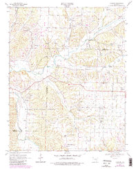
1970 Map of Robinson
USGS Topo · Published 1983About this map
Ozark National Forest lands dominate the southwestern portion of this survey, where the Illinois River cuts through the topography near the Benton and Washington County line. The landscape is defined by the winding course of Osage Creek and its many tributaries, including Lick Branch and Wildcat Creek. This region of Northwest Arkansas shows a well-established network of rural institutions, such as Rocks Comfort Ch, Pleasant Hill Ch, and the University of Arkansas Agricultural Experiment Station. Small communities like Robinson, Harmon, and the western edge of Tontitown serve as focal points for the surrounding agricultural tracts. Local history is preserved in sites like Yell Cem and the Community Hall near Harmon Ch, illustrating the social and religious infrastructure of these upland settlements during the mid-to-late twentieth century.
Find a feature on this map
23 named features on this map. Tap any name to fly to it.
Don’t see what you’re looking for? This feature index may not catch every label — zoom into the map to look around manually.
Map Details
Editions of this 1970 Robinson Map
3 editions found
Other maps of this area

1899 · Fayetteville
USGS Topo · 1:125,000

1901 · Fayetteville
USGS Topo · 1:125,000

1904 · Fayetteville
USGS Topo · 1:125,000

1954 · Tulsa
USGS Topo · 1:250,000

1958 · Fayetteville
USGS Topo · 1:24,000

1958 · Tulsa
USGS Topo · 1:250,000

1963 · Tulsa
USGS Topo · 1:250,000

1970 · Gallatin
USGS Topo · 1:24,000

1970 · Robinson
USGS Topo · 1:24,000
1970 · Bentonville South
USGS Topo · 1:24,000