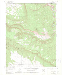
1960 Map of Roc Creek
USGS Topo · Published 1981About this map
The Manti-La Sal National Forest dominates this 1960 revision of the Roc Creek area, where the rugged terrain of the Colorado Plateau meets an active mid-century mining economy. The landscape is defined by the high elevations of Sewemup Mesa and the long, sweeping curve of Carpenter Ridge, while the Dolores River cuts through the northeastern corner. Evidence of the region’s uranium and vanadium booms is visible in the cluster of workings such as the Rajah Mine, Redbird Mine, and the Radium Cycle Mine. These sites, alongside the Sunrise Mine in Sunrise Canyon, highlight a period when the canyon country was being intensively explored for radioactive ores. In the lower elevations, the Sinbad Valley and the Pace Ranch represent the persistent agricultural and ranching efforts that have long occupied these remote basins between the ridges.
Find a feature on this map
24 named features on this map. Tap any name to fly to it.
Don’t see what you’re looking for? This feature index may not catch every label — zoom into the map to look around manually.
Map Details
Editions of this 1960 Roc Creek Map
3 editions found
Other maps of this area

1885 · La Sal
USGS Topo · 1:250,000

1916 · Paradox Valley
USGS Topo · 1:125,000

1922 · Paradox Valley
USGS Topo · 1:125,000

1948 · Roc Creek
USGS Topo · 1:24,000

1948 · Paradox
USGS Topo · 1:24,000

1949 · Davis Mesa
USGS Topo · 1:24,000

1949 · Paradox
USGS Topo · 1:24,000

1949 · Roc Creek
USGS Topo · 1:24,000

1949 · Juanita Arch
USGS Topo · 1:24,000

1949 · Red Canyon
USGS Topo · 1:24,000