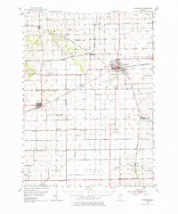
1952 Map of Rochelle
USGS Topo · Published 1976About this map
The railroad junction at Rochelle dominates this mid-century portrait of the northern Illinois prairie, where the Chicago and North Western and Chicago Burlington and Quincy lines intersect. This mapping reveals a landscape organized by strict townships like Dement and Lafayette, dotted with one-room schoolhouses that served the agricultural community before widespread consolidation. Features such as Antioch Sch, Yorty Sch, and Stonehill Sch appear alongside rural burial grounds like Chapel Hill Cem and Reynolds Cem. Waterways like the Kyte River and Willow Creek cut through the fields, while the concentration of Gravel Pits and a Quarry near the municipal centers points to the local industry supporting regional road and rail development during this era of post-war growth.
Find a feature on this map
53 named features on this map. Tap any name to fly to it.
Don’t see what you’re looking for? This feature index may not catch every label — zoom into the map to look around manually.
Map Details
Editions of this 1952 Rochelle Map
3 editions found

Other maps of this area

1917 · Kings
USGS Topo · 1:62,500

1918 · Dixon
USGS Topo · 1:62,500

1918 · Kings
USGS Topo · 1:62,500

1918 · Kirkland
USGS Topo · 1:62,500

1922 · Oregon
USGS Topo · 1:62,500

1924 · Oregon
USGS Topo · 1:62,500

1934 · De Kalb
USGS Topo · 1:62,500

1937 · De Kalb
USGS Topo · 1:62,500

1950 · Dixon
USGS Topo · 1:62,500

1951 · Amboy
USGS Topo · 1:62,500