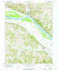
1952 Map of Rocheport
USGS Topo · Published 1976About this map
The Missouri River carves a deep valley through this mid-century landscape, serving as a boundary between several Central Missouri counties. On its north bank, the town of Rocheport sits near the mouth of Moniteau Creek, while the settlement of Overton occupies the southern bottomlands. The river corridor is dominated by the industrial presence of the Missouri Pacific railroad, which parallels the water's edge. South of the river, the terrain rises into the sharp ridges and creek valleys of the Saline and Linn districts. This area is dotted with remote rural landmarks, including the Gooch Mill Ch and Highland Ch, alongside several family burying grounds such as Schmidt Cem and Clayton Cem. The presence of Rocheport Cave and a Rock Quarry near McGill Branch highlights the area's karst topography and early resource extraction efforts along the limestone bluffs.
Find a feature on this map
35 named features on this map. Tap any name to fly to it.
Don’t see what you’re looking for? This feature index may not catch every label — zoom into the map to look around manually.
Map Details
Editions of this 1952 Rocheport Map
4 editions found
Other maps of this area

1886 · Jefferson City
USGS Topo · 1:125,000

1888 · Boonville
USGS Topo · 1:125,000

1890 · Moberly
USGS Topo · 1:125,000

1890 · Glasgow
USGS Topo · 1:125,000

1894 · Jefferson City
USGS Topo · 1:125,000

1917 · Sturgeon
USGS Topo · 1:62,500

1947 · Jefferson City
USGS Topo · 1:250,000

1948 · Columbia
USGS Topo · 1:62,500

1950 · Columbia
USGS Topo · 1:62,500

1952 · Rocheport
USGS Topo · 1:24,000