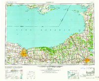
1960 Map of Rochester
USGS Topo · Published 1960About this map
Rochester anchors this regional perspective of the Lake Ontario shoreline, where the industrial and transport networks of mid-century New York meet the maritime geography of the international border. The landscape is defined by the heavy infrastructure of the New York Central railroad, which links established manufacturing centers like Fulton and Newark to the bustling port at Rochester. Along the northern coast, the military presence at Picton R C A F and several lighthouses, including the Presqu'ile Point Lighthouse and Peter Point Lighthouse, underscore the strategic and navigational importance of these waters during the Cold War era.
Find a feature on this map
298 named features on this map. Tap any name to fly to it.
Don’t see what you’re looking for? This feature index may not catch every label — zoom into the map to look around manually.
Map Details
Editions of this 1960 Rochester Map
2 editions found

Other maps of this area

1893 · Sackets Harbor
USGS Topo · 1:62,500

1895 · Chittenango
USGS Topo · 1:62,500

1895 · Sacketts Harbor
USGS Topo · 1:62,500

1895 · Rochester
USGS Topo · 1:62,500

1895 · Stony Island
USGS Topo · 1:62,500

1895 · Ontario Beach
USGS Topo · 1:62,500

1895 · Pulaski
USGS Topo · 1:62,500

1895 · Watertown
USGS Topo · 1:62,500

1895 · Cape Vincent
USGS Topo · 1:62,500

1895 · Syracuse
USGS Topo · 1:62,500