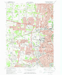
1971 Map of Rochester West
USGS Topo · Published 1974About this map
The Genesee River carves the eastern edge of this 1971 landscape, anchoring a dense network of suburban growth and industrial infrastructure northwest of Rochester. The area is defined by its deep Catholic educational and memorial roots, evidenced by the sprawling grounds of Holy Sepulchre Cemetery and the St Bernards Seminary. Further west, the legacy of the Erie Canal remains a visible artery through North Gates and South Greece, running parallel to the heavy rail lines of the Penn Central.
Find a feature on this map
93 named features on this map. Tap any name to fly to it.
Don’t see what you’re looking for? This feature index may not catch every label — zoom into the map to look around manually.
Map Details
Editions of this 1971 Rochester West Map
4 editions found
Other maps of this area

1895 · Rochester
USGS Topo · 1:62,500

1895 · Ontario Beach
USGS Topo · 1:62,500

1898 · Rochester
USGS Topo · 1:62,500

1899 · Hamlin
USGS Topo · 1:62,500

1899 · Ontario Beach
USGS Topo · 1:62,500

1899 · Brockport
USGS Topo · 1:62,500

1912 · Rochester
USGS Topo · 1:62,500

1912 · Ontario Beach
USGS Topo · 1:62,500

1920 · Rochester
USGS Topo · 1:62,500

1931 · Mendon Ponds
USGS Topo · 1:24,000