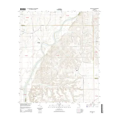
2015 Map of Rock Bluff
USGS Topo · Published 2015About this map
The Apalachicola River carves a sweeping path through this landscape, marking the transition between Calhoun, Gadsden, and Liberty counties. The settlement of Rock Bluff stands on the eastern heights overlooking the river, while Ocheesee Landing serves as a historical point of access to the water on the western bank. To the south, the community of Sweetwater is situated near the complex drainage system of Big Sweetwater Cr and Upper Sweetwater Cr, where a dense network of local roads such as NW Redie Dawson Rd and NW Harry Donar Rd connect rural homesteads.
Find a feature on this map
72 named features on this map. Tap any name to fly to it.
Don’t see what you’re looking for? This feature index may not catch every label — zoom into the map to look around manually.
Map Details
Editions of this 2015 Rock Bluff Map
This is the sole edition of this map. No revisions or reprints were ever made.
Other maps of this area

1945 · Blountstown
USGS Topo · 1:31,680

1945 · Hosford
USGS Topo · 1:31,680

1945 · Bristol
USGS Topo · 1:31,680

1952 · Cypress
USGS Topo · 1:24,000

1952 · Altha East
USGS Topo · 1:24,000

1954 · Sneads
USGS Topo · 1:24,000

1954 · Tallahassee
USGS Topo · 1:250,000

1955 · Rock Bluff
USGS Topo · 1:24,000

1955 · Sycamore
USGS Topo · 1:24,000

1955 · Chattahoochee
USGS Topo · 1:24,000