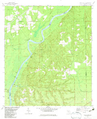
1982 Map of Rock Bluff
USGS Topo · Published 1983About this map
The Apalachicola River winds through a landscape defined by sharp bluffs and complex river landings in the early 1980s. This region, centered on Torreya State Park, illustrates a transition from the elevated terrain of Hickory Hill and Logan Hill to the fertile riverbanks. Historically significant river access points like Aspalaga Landing, Ocheesee Landing, and Johnson Landing highlight the importance of the waterway for local transport.
Find a feature on this map
49 named features on this map. Tap any name to fly to it.
Don’t see what you’re looking for? This feature index may not catch every label — zoom into the map to look around manually.
Map Details
Editions of this 1982 Rock Bluff Map
This is the sole edition of this map. No revisions or reprints were ever made.
Other maps of this area

1945 · Blountstown
USGS Topo · 1:31,680

1945 · Hosford
USGS Topo · 1:31,680

1945 · Bristol
USGS Topo · 1:31,680

1952 · Cypress
USGS Topo · 1:24,000

1952 · Altha East
USGS Topo · 1:24,000

1954 · Sneads
USGS Topo · 1:24,000

1954 · Tallahassee
USGS Topo · 1:250,000

1955 · Rock Bluff
USGS Topo · 1:24,000

1955 · Sycamore
USGS Topo · 1:24,000

1955 · Chattahoochee
USGS Topo · 1:24,000