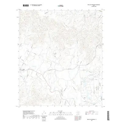
2019 Map of Rock Cliff Reservoir
USGS Topo · Published 2019About this map
Medina serves as the primary hub in this Hill Country landscape, situated where the Medina River begins its winding course through the valley. The terrain is defined by a dense network of drainages and canyons, including Crow Canyon and Prison Canyon to the northeast, which feed into the area's complex hydrology. This 2019 survey illustrates the rural infrastructure of Bandera County, characterized by private ranch lands and small aviation facilities like T-4 Ranch Airport and Flying L Airport. Local connectivity is maintained through a web of named ranch roads and lanes, such as Ranch Rd 2828 and Moseley Ranch Rd, which navigate the elevation changes between the peaks and the riverbed. Smaller bodies of water like Hadfield Lake and Thallman Lake appear as localized landmarks amidst the sprawling ranching estates that dominate the region's geography.
Find a feature on this map
56 named features on this map. Tap any name to fly to it.
Don’t see what you’re looking for? This feature index may not catch every label — zoom into the map to look around manually.
Map Details
Editions of this 2019 Rock Cliff Reservoir Map
This is the sole edition of this map. No revisions or reprints were ever made.
Other maps of this area

1954 · San Antonio
USGS Topo · 1:250,000

1956 · Tarpley
USGS Topo · 1:62,500

1956 · Tuff
USGS Topo · 1:62,500

1956 · Bandera
USGS Topo · 1:62,500

1956 · Center Point
USGS Topo · 1:62,500

1957 · San Antonio
USGS Topo · 1:250,000

1964 · Center Point
USGS Topo · 1:24,000

1964 · Echo Hill Ranch
USGS Topo · 1:24,000

1964 · Bandera
USGS Topo · 1:24,000

1964 · Rock Cliff Reservoir
USGS Topo · 1:24,000