
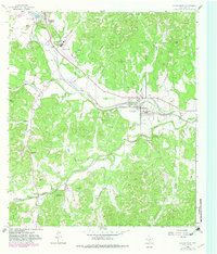
1964 Map of Center Point
USGS Topo · Published 1966About this map
The Guadalupe River carves a deep valley through the heart of the Texas Hill Country, anchoring the settlement of Center Point during the mid-1960s. The landscape reflects a transition from traditional ranching to modern infrastructure, where the Southern Pacific railroad runs parallel to the river, and the Kerrville Municipal Airport occupies the northern flats near Guadalupe Heights. Local history is deeply embedded in the terrain, from the legacy of Old Camp Verde in the southwest corner to family landmarks like the Wharton Cem. The rugged topography is defined by numerous hollows and peaks, including Pikes Peak and Lookout Mountain, which overlook the winding course of Verde Creek and Turtle Creek. Small communities and camps, such as Shady Grove and Camp Christian, are scattered throughout the valleys, illustrating the area's dual role as a rural agricultural zone and a destination for recreation along the river banks.
Find a feature on this map
42 named features on this map. Tap any name to fly to it.
Don’t see what you’re looking for? This feature index may not catch every label — zoom into the map to look around manually.
Map Details
Editions of this 1964 Center Point Map
2 editions found
Other maps of this area

1894 · Fredericksburg
USGS Topo · 1:125,000

1894 · Kerrville
USGS Topo · 1:125,000

1954 · Llano
USGS Topo · 1:250,000

1954 · San Antonio
USGS Topo · 1:250,000

1955 · Llano
USGS Topo · 1:250,000

1956 · Comfort
USGS Topo · 1:62,500

1956 · Center Point
USGS Topo · 1:62,500

1956 · Llano
USGS Topo · 1:250,000

1957 · San Antonio
USGS Topo · 1:250,000

1964 · Comfort
USGS Topo · 1:24,000