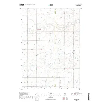
2019 Map of Rock Dell
USGS Topo · Published 2019About this map
The S Fork Zumbro River and Salem Cr define the drainage of this agricultural landscape along the border of Dodge and Olmsted counties. The small settlement of Rock Dell sits at the junction of several county roads, serving as a focal point for the surrounding farmsteads. Genealogical interest is high in this quadrangle, as it contains four distinct burial grounds: South Zumbro Cem, West Saint Olaf Cem, East Saint Olaf Cem, and Zion Cem. These sites, along with small community centers like Oslo and the curiously named Shanty Town, provide evidence of the area's early Norwegian-American heritage and settlement patterns. The map's grid-like road system, featuring routes like CO Hwy 17 and CO Rd K, illustrates how the Public Land Survey System shaped the modern Minnesota countryside.
Find a feature on this map
38 named features on this map. Tap any name to fly to it.
Don’t see what you’re looking for? This feature index may not catch every label — zoom into the map to look around manually.
Map Details
Editions of this 2019 Rock Dell Map
This is the sole edition of this map. No revisions or reprints were ever made.
Other maps of this area

1953 · Saint Paul
USGS Topo · 1:250,000

1954 · Mason City
USGS Topo · 1:250,000

1955 · High Forest
USGS Topo · 1:62,500

1957 · Mason City
USGS Topo · 1:250,000

1958 · Mason City
USGS Topo · 1:250,000

1959 · Saint Paul
USGS Topo · 1:250,000

1965 · Dodge Center
USGS Topo · 1:24,000

1965 · Byron
USGS Topo · 1:24,000

1966 · Douglas
USGS Topo · 1:24,000
1966 · Hayfield
USGS Topo · 1:24,000