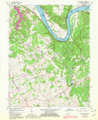
1960 Map of Rock Haven
USGS Topo · Published 1981About this map
Otter Creek Park and the sprawling Fort Knox Military Reservation dominate this section of the Kentucky-Indiana border, where the Ohio River carves a deep valley through the limestone landscape. The riverfront is marked by numerous historic river access points such as Cedar Farm Landing, Hughes Landing, and Gurley Landing, reflecting the era's reliance on the waterway and the adjacent Nashville and Louisville RR for transport.
Find a feature on this map
74 named features on this map. Tap any name to fly to it.
Don’t see what you’re looking for? This feature index may not catch every label — zoom into the map to look around manually.
Map Details
Editions of this 1960 Rock Haven Map
Other maps of this area

1909 · Kosmosdale
USGS Topo · 1:48,000

1912 · Kosmosdale
USGS Topo · 1:62,500

1931 · Corydon
USGS Topo · 1:62,500

1936 · Vine Grove
USGS Topo · 1:62,500

1941 · Ekron
USGS Topo · 1:62,500

1943 · Vine Grove
USGS Topo · 1:62,500

1946 · Rock Haven
USGS Topo · 1:24,000

1946 · Fort Knox
USGS Topo · 1:24,000

1946 · Vine Grove
USGS Topo · 1:24,000

1946 · Vine Grove
USGS Topo · 1:62,500