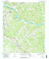
1968 Map of Rock Hill East
USGS Topo · Published 1988About this map
The Catawba River winds through this 1968 survey, separating Fort Mill and the eastern reaches of Rock Hill. The landscape is defined by its transition from industrial utility to rural community, with the Southern railroad line cutting a straight path through the topography near the settlement of Lesslie. Local life centers around numerous small congregations, including Kingdom Hall Ch, Foundation Ch, and Mt Hebron Ch, which anchor the small crossroads and hillsides.
Find a feature on this map
46 named features on this map. Tap any name to fly to it.
Don’t see what you’re looking for? This feature index may not catch every label — zoom into the map to look around manually.
Map Details
Editions of this 1968 Rock Hill East Map
4 editions found
Other maps of this area

1905 · Charlotte
USGS Topo · 1:48,000

1907 · Charlotte
USGS Topo · 1:62,500

1941 · Charlotte
USGS Topo · 1:125,000

1941 · Spartanburg
USGS Topo · 1:250,000

1942 · Charlotte
USGS Topo · 1:125,000

1947 · Clover
USGS Topo · 1:62,500

1949 · Clover
USGS Topo · 1:62,500

1949 · Rock Hill
USGS Topo · 1:62,500

1953 · Spartanburg
USGS Topo · 1:250,000

1953 · Charlotte
USGS Topo · 1:250,000