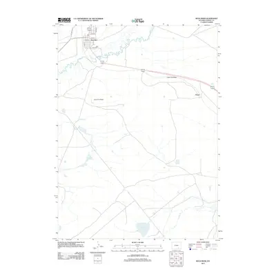
2012 Map of Rock River
USGS Topo · Published 2012About this map
Rock River serves as the primary hub in this High Plains landscape, where residential streets like Lewis Ave and Avenue D meet the winding course of the river itself. The settlement is positioned along the transit corridor of Old State Hwy 13, which parallels the modern highway route. To the southeast, the small settlement of Harper sits near the base of Lower Pine Ridge, a significant geological transition that separates the river valley from the elevated flats. The hydrology of the area is defined by seasonal and perennial water sources, including the drainage of Coalbank Cr into the Coalbank Reservoir and the isolated Rainey Lake to the south. This survey illustrates the sparse, ranching-oriented grid of Albany County, where long-distance roads such as Schultz Rd and Reed connect isolated family landmarks and water rights across the open range.
Find a feature on this map
17 named features on this map. Tap any name to fly to it.
Don’t see what you’re looking for? This feature index may not catch every label — zoom into the map to look around manually.
Map Details
Editions of this 2012 Rock River Map
This is the sole edition of this map. No revisions or reprints were ever made.
Other maps of this area

1915 · Como Ridge
USGS Topo · 1:48,000

1918 · Como Ridge
USGS Topo · 1:62,500

1954 · Cheyenne
USGS Topo · 1:250,000

1954 · Rawlins
USGS Topo · 1:250,000

1955 · Big Judson
USGS Topo · 1:24,000

1955 · Cooper Lake South
USGS Topo · 1:24,000

1955 · Cooper Lake North
USGS Topo · 1:24,000

1955 · Rock River
USGS Topo · 1:24,000

1955 · Cannonball Cut
USGS Topo · 1:24,000

1955 · Wilcox
USGS Topo · 1:24,000