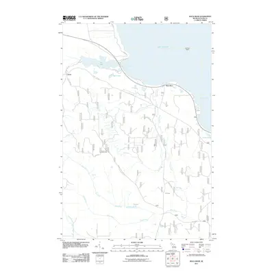
2011 Map of Rock River
USGS Topo · Published 2011About this map
Onota and the mouth of the Rock River anchor this 2011 survey of the Lake Superior coastline in Alger County. The landscape is defined by the complex drainage of the Rock River watershed, featuring Rock River Falls and the secluded Silver Falls along its tributaries. A network of Forest Service roads, such as USFS 2484 Rd and USFS 2276 Rd, provides access to interior points of interest including the CCC Camp and the Johnson Lake Lookout Tower. The northern edge follows the irregular shoreline from Shelter Bay to Au Train Bay, overlooking the prominent Au Train Island. Inland, numerous small water bodies like Spirit Lake, Deer Lake, and Ginpole Lake dot the forested terrain, reflecting the area's history of recreation and resource management in the Upper Peninsula.
Find a feature on this map
35 named features on this map. Tap any name to fly to it.
Don’t see what you’re looking for? This feature index may not catch every label — zoom into the map to look around manually.
Map Details
Editions of this 2011 Rock River Map
This is the sole edition of this map. No revisions or reprints were ever made.
Other maps of this area

1932 · Skandia SE
USGS Topo · 1:31,680

1932 · Skandia NE
USGS Topo · 1:31,680

1958 · Au Train
USGS Topo · 1:62,500

1958 · Laughing Fish Point
USGS Topo · 1:62,500

1958 · Skandia
USGS Topo · 1:62,500

1958 · Marquette
USGS Topo · 1:250,000

1960 · Marquette
USGS Topo · 1:250,000

1961 · Marquette
USGS Topo · 1:250,000

1968 · Marquette
USGS Topo · 1:250,000
1983 · Gwinn
USGS Topo · 1:100,000
Featured Places
- Rock River, Onota Township
- Rock River Township, MI
- Onota Township, MI
- Onata, Onota Township
- Alger County, MI