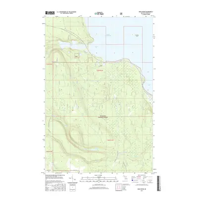
2017 Map of Rock River
USGS Topo · Published 2017About this map
Lake Superior dominates the northern horizon of this Upper Peninsula landscape, where the shoreline is punctuated by Shelter Bay and the prominent Au Train Island. In the rugged interior of the Hiawatha National Forest, the Rock River and its tributaries carve through the terrain, creating notable landmarks like Rock River Falls and Silver Falls. The map reveals a land defined by water and heavy forest, with scattered inland bodies such as Deer Lake and Ginpole Lake sitting among the ridges of Hemlock Bluff. Human presence is marked primarily by recreational and service infrastructure, including segments of the N Country National Scenic Trail and local routes like Shore Dr and Co Hwy 466. A unique point of local history is preserved at Trudell's Graves, a small site located just south of the Lake Superior coast.
Find a feature on this map
33 named features on this map. Tap any name to fly to it.
Don’t see what you’re looking for? This feature index may not catch every label — zoom into the map to look around manually.
Map Details
Editions of this 2017 Rock River Map
This is the sole edition of this map. No revisions or reprints were ever made.
Other maps of this area

1932 · Skandia SE
USGS Topo · 1:31,680

1932 · Skandia NE
USGS Topo · 1:31,680

1958 · Au Train
USGS Topo · 1:62,500

1958 · Laughing Fish Point
USGS Topo · 1:62,500

1958 · Skandia
USGS Topo · 1:62,500

1958 · Marquette
USGS Topo · 1:250,000

1960 · Marquette
USGS Topo · 1:250,000

1961 · Marquette
USGS Topo · 1:250,000

1968 · Marquette
USGS Topo · 1:250,000
1983 · Gwinn
USGS Topo · 1:100,000
Featured Places
- Rock River, Onota Township
- Rock River Township, MI
- Onota Township, MI
- Onata, Onota Township
- Alger County, MI