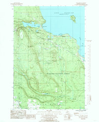
1985 Map of Rock River
USGS Topo · Published 1985About this map
Old Charcoal Kilns Ruins (Historic Site) sit along the shores of Lake Superior, marking the industrial history of this Upper Peninsula landscape. Within the Hiawatha National Forest, the map captures the transition from heavy rail-based industry to a more recreational and managed forest environment. The transportation network is defined by the Soo Line and remnants of an Old RR Grade that once hauled timber and charcoal through the interior. Settlements such as Onota and Rock River are recorded alongside natural landmarks like Rock River Falls and Silver Falls. The presence of a Cem near the coast and several named ponds and creeks, such as Ginpole Lake and Slapneck Creek, provides specific points of interest for local history and genealogy research in this corner of Alger County.
Find a feature on this map
27 named features on this map. Tap any name to fly to it.
Don’t see what you’re looking for? This feature index may not catch every label — zoom into the map to look around manually.
Map Details
Editions of this 1985 Rock River Map
This is the sole edition of this map. No revisions or reprints were ever made.
Other maps of this area

1932 · Skandia SE
USGS Topo · 1:31,680

1932 · Skandia NE
USGS Topo · 1:31,680

1958 · Au Train
USGS Topo · 1:62,500

1958 · Laughing Fish Point
USGS Topo · 1:62,500

1958 · Skandia
USGS Topo · 1:62,500

1958 · Marquette
USGS Topo · 1:250,000

1960 · Marquette
USGS Topo · 1:250,000

1961 · Marquette
USGS Topo · 1:250,000

1968 · Marquette
USGS Topo · 1:250,000
1983 · Gwinn
USGS Topo · 1:100,000
Featured Places
- Rock River, Onota Township
- Onata, Onota Township
- Onota Township, MI
- Rock River Township, MI
- Alger County, MI