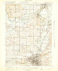
1918 Map of Rockford
USGS Topo · Published 1918About this map
Rockford expands northward along the Rock River in the years following the Great War, its industrial and residential growth tied to a dense network of rail lines including the Chicago Milwaukee and St Paul and the Chicago and Northwestern. Rural Winnebago County remains defined by a grid of schoolhouse districts, such as Whig Hill School and Bird School, and institutional sites like the Winnebago County Boys Reform School. The map reveals the early importance of electric transit, with the Rockford and Interurban Electric line connecting the city to peripheral communities like Loves Park and Roscoe. To the north, the confluence of the Sugar River and Pecatonica River highlights the natural hydrology that dictated early settlement patterns near Harrison and Shirland.
Find a feature on this map
77 named features on this map. Tap any name to fly to it.
Don’t see what you’re looking for? This feature index may not catch every label — zoom into the map to look around manually.
Map Details
Editions of this 1918 Rockford Map
3 editions found
Other maps of this area

1891 · Janesville
USGS Topo · 1:62,500

1893 · Janesville
USGS Topo · 1:62,500

1893 · Brodhead
USGS Topo · 1:62,500

1893 · Shopiere
USGS Topo · 1:62,500

1917 · Kings
USGS Topo · 1:62,500

1918 · Rockford
USGS Topo · 1:62,500

1918 · Belvidere
USGS Topo · 1:62,500

1918 · Kings
USGS Topo · 1:62,500

1918 · Kirkland
USGS Topo · 1:62,500

1922 · Oregon
USGS Topo · 1:62,500