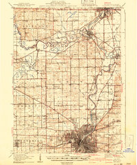
1918 Map of Rockford
USGS Topo · Published 1941About this map
Rockford dominates the southern portion of this landscape at the confluence of the Rock River and Kent Creek, showing the city's early industrial grid and rail corridors before the major post-war expansions. To the north, the river winds past Loves Park and Latham Park toward the established riverside communities of Rockton and South Beloit. The region is defined by a heavy concentration of rural one-room schoolhouses, such as Bird School, Mud School, and Sand Prairie School, which served the farming townships of Owen, Burritt, and Harrison. In the southeast, Camp Grant appears in its pre-WWII footprint along the riverbanks. The transportation network is anchored by the Chicago Milwaukee St. Paul and Pacific and the Chicago and Northwestern railroads, which linked these northern Illinois agricultural centers to the growing urban hubs at the Wisconsin border.
Find a feature on this map
71 named features on this map. Tap any name to fly to it.
Don’t see what you’re looking for? This feature index may not catch every label — zoom into the map to look around manually.
Map Details
Editions of this 1918 Rockford Map
3 editions found
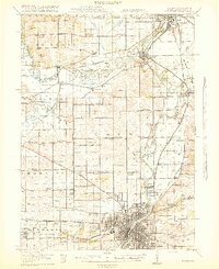
Other maps of this area

1891 · Janesville
USGS Topo · 1:62,500

1893 · Janesville
USGS Topo · 1:62,500

1893 · Brodhead
USGS Topo · 1:62,500

1893 · Shopiere
USGS Topo · 1:62,500

1917 · Kings
USGS Topo · 1:62,500

1918 · Rockford
USGS Topo · 1:62,500

1918 · Belvidere
USGS Topo · 1:62,500

1918 · Kings
USGS Topo · 1:62,500

1918 · Kirkland
USGS Topo · 1:62,500

1922 · Oregon
USGS Topo · 1:62,500