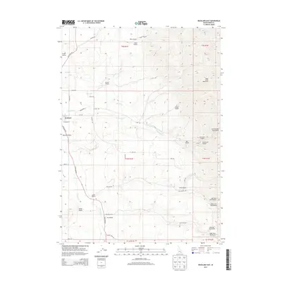
2013 Map of Rockland East
USGS Topo · Published 2013About this map
Rockland and the surrounding Rockland Valley are situated at the western base of the Deep Creek Mountains, where the high desert terrain is marked by a complex system of canyons and drainage ditches. The landscape is defined by its water management and distinct landforms, including the prominent Mollys Nipple and the winding course of the S Fork Rock Cr. This area of Power County is characterized by a grid of rural roads and irrigation works like the Bench Ditch, which support the local agriculture in this high-altitude valley. The map reveals the relationship between the seasonal water sources from Water Canyon and Well Canyon and the developed settlements. Genealogists and local historians can trace the naming of the landscape through numerous family-named canyons, such as Hunter Canyon, Lewis Canyon, and Hutchinson Canyon, which punctuate the slopes of the mountains rising to the east.
Find a feature on this map
51 named features on this map. Tap any name to fly to it.
Don’t see what you’re looking for? This feature index may not catch every label — zoom into the map to look around manually.
Map Details
Editions of this 2013 Rockland East Map
This is the sole edition of this map. No revisions or reprints were ever made.
Other maps of this area

1934 · Rockland
USGS Topo · 1:62,500

1937 · Rockland
USGS Topo · 1:62,500

1938 · Pauline
USGS Topo · 1:48,000

1944 · Arbon
USGS Topo · 1:62,500

1954 · Pocatello
USGS Topo · 1:250,000

1958 · Pocatello
USGS Topo · 1:250,000

1971 · Rockland East
USGS Topo · 1:24,000

1971 · Bannock Peak
USGS Topo · 1:24,000
1971 · Sawmill Creek
USGS Topo · 1:24,000
1971 · Indian Springs
USGS Topo · 1:24,000