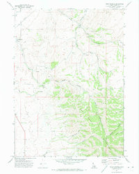
1971 Map of Indian Springs
USGS Topo · Published 1974About this map
The Deep Creek Mountains dominate this 1970s landscape, where steep canyons and complex drainage networks define the terrain of Power County. Water is the primary architect here, with Warm Creek and Cold Creek cutting through the highlands alongside various named Springs. These water sources likely supported the small-scale ranching and mining activities indicated by the Garden Ranch in the north and the cluster of Mines situated above the canyon walls.
Find a feature on this map
25 named features on this map. Tap any name to fly to it.
Don’t see what you’re looking for? This feature index may not catch every label — zoom into the map to look around manually.
Map Details
Editions of this 1971 Indian Springs Map
This is the sole edition of this map. No revisions or reprints were ever made.
Other maps of this area

1934 · American Falls
USGS Topo · 1:62,500

1934 · Michaud
USGS Topo · 1:62,500

1934 · Rockland
USGS Topo · 1:62,500

1936 · American Falls
USGS Topo · 1:62,500

1937 · Rockland
USGS Topo · 1:62,500

1937 · Michaud
USGS Topo · 1:62,500

1938 · Pauline
USGS Topo · 1:48,000

1944 · Arbon
USGS Topo · 1:62,500

1954 · Pocatello
USGS Topo · 1:250,000

1958 · Pocatello
USGS Topo · 1:250,000