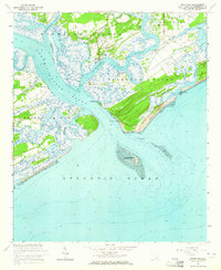
1960 Map of Rockville
USGS Topo · Published 1964About this map
Bohicket Creek winds past the small settlement of Rockville, marking a landscape defined by expansive tidal marshes and shifting coastal barrier islands. At this mid-century period, the area maintains its maritime character, with Wadmalaw Island and Johns Island separated by narrow waterways and old telephone lines. The transition from terrestrial forest to sea is punctuated by several historically significant plantations and points, such as Point of Pines on Edisto Island and the isolated fishing camps at Camp St Christopher. South of the North Edisto River, the coastline is highly dynamic, showing the complex shapes of Botany Bay Island and the exposed Deveaux Bank in the Atlantic Ocean. The presence of St Johns Ch on Johns Island and the settlement of Rockland indicate the long-standing community centers that serve this water-dependent geography.
Find a feature on this map
37 named features on this map. Tap any name to fly to it.
Don’t see what you’re looking for? This feature index may not catch every label — zoom into the map to look around manually.
Map Details
Editions of this 1960 Rockville Map
4 editions found
Other maps of this area

1918 · Kiawah Island
USGS Topo · 1:21,120

1919 · Edisto Island
USGS Topo · 1:62,500

1919 · Wadmelaw Island
USGS Topo · 1:62,500

1919 · Legareville
USGS Topo · 1:21,120

1920 · St. Helena Sound
USGS Topo · 1:62,500

1943 · Legareville
USGS Topo · 1:24,000

1943 · Edisto Island
USGS Topo · 1:62,500

1943 · Kiawah Island
USGS Topo · 1:24,000

1944 · Wadmelaw Island
USGS Topo · 1:62,500

1947 · Savannah
USGS Topo · 1:250,000